


Technology can be seductive, particularly in healthcare. Unfortunately, all too often the focus of programs and ‘research’ becomes the technology itself rather than the outcome. Informatics based early warning systems for epidemics are a step in the right direction.
Control of communicable diseases has been a tremendous challenge to the public health machinery in the developing world. A variety of reasonable and scientifically valid interventions directed at each step of the different disease processes have been identified and attempted. However, there is still an unacceptable level of failure of the public health apparatus in preventing and eradicating communicable diseases that cause enormous morbidity and mortality. While the reasons for failure may be multifactoral, one important contributor is the sub-optimal use of existing public health resources to deliver the greatest benefit for the greatest number. Clearly, if technology can be used appropriately to positively influence outcomes in such a circumstance, the social benefits would be immense. And an E-health approach that shows increasing promise is the development of Early Warning Response Systems (EWRS), which uses satellite imagery acquired by remote sensing as well as environmental data such as meteorological conditions to try and predict the onset of an epidemic, often in conjunction with Geographic Information Systems (GIS). The greatest attention has been given to diseases borne by vectors like mosquitoes, birds and animals as well as to waterborne diseases like cholera facilitated by the presence of plankton. Efforts at developing successful models have been driven by researchers as well as official bodies like the World Health Organisation (WHO) and various space agencies like the US National Aeronautics and Space Administration (NASA), the European Space Agency (ESA) and the Indian Space Research Organisation (ISRO). Some examples of the work and programs to date are discussed below.
In 1985, NASA initiated the Biospheric Monitoring and Disease Prediction Project, the aim of which was to determine if remotely sensed data could be used to identify and monitor environmental factors that influence malaria vector populations. Initial studies used high-resolution images from LANDSAT to monitor the development of canopy cover in Californian rice fields. Changes in rice canopy cover over the season were successfully used to predict fields with high or low mosquito densities.
Another NASA project that is currently underway is the Malaria Modeling and Surveillance Project by the Armed Forces Research Institute of Medical Sciences in Thailand and the US Naval Medical Research Unit in Indonesia.

The European Space Agency’s two-year Epidemio project, launched in 2004, combined data from Earth Observation satellites, such as ESA’s Envisat or the French Space Agency’s Spot, with field work to combat the spread of epidemics. Specific situations in which Epidemio assisted in the analysis of and response to epidemics include studies of Ebola hemorrhagic fever in Congo and Gabon. Combining ESA Envisat satellite data on water bodies, forest cover and digital elevation models (DEMs) with field results, scientists were able to identify dryness and drought as key factors connected to the Ebola epidemics. High-resolution images through Epidemio also helped in controlling an outbreak of the Marburg virus in Angola in 2005.

In China, there have been recent studies on Highly Pathogenic Avian Influenza, identifying risk factors for transmission. A study published in 2008 compared confirmed HPAI H5N1 outbreaks in poultry and wild birds, as well as 21 human cases in Mainland China during 2004-2006. These data, together with information on wild bird migration, poultry densities, and environmental variables (water bodies, wetlands, transportation routes, main cities, precipitation and elevation), were integrated into a Geographical Information System. A case-control design was followed by multivariate logistic regression analysis which revealed that minimal distance to the nearest national highway, annual precipitation and the interaction between minimal distance to the nearest lake and wetland, were important predictive environmental variables for the risk of HPAI.
A variety of internationally connected efforts are active in various parts of Africa to use RS and GIS for control of Malaria, Leishmaniasis and other vector borne disorders, particularly focusing on weather anomalies and rainfall related indices.
There have been a number of studies in India with the assistance of ISRO that have also uated the use of remote sensing with and without GIS, studying Japanese Encephalitis (JE) in the North-East and in South India, Filariasis in South India, Cholera in West Bengal and Malaria near Delhi, all showing promising results.
The examples highlighted are credible attempts to further our ability to use the unique possibilities afforded by RS towards epidemic prevention. A desirable derivative of such projects is the cross-border cooperation that is a natural consequence. International cooperation fostered by such activities directed to the common good not only help to protect global health, but also sets new standards for political intercourse, replacing suspicion and strategy with trust and collaboration.
Evolutionary Concepts
As we have seen, early warning systems utilising remote sensing and GIS are not new. One of the groups working on expanding the use and utility of such techniques for infectious diseases is the United Nations Committee on the Peaceful Uses of Outer Space (COPUOS) Action Team 6 (AT 6) that the author has been a member of since 2007. Its mission is to improve public health through the use of space-based technologies. Delegates have been encouraged to work together to develop projects and concepts that have the potential to positively impact public health. In this context, a collaborative group was formed under the broad umbrella of AT 6 which includes physicians, mathematicians, logisticians, health economists, entomologists, remote sensing experts and social scientists drawn from Germany, South Africa, the United States, India and Canada. A concept has been developed that a multidisciplinary informatics scaffold can serve as an Early Warning and Automated Response System (EWARS) for communicable diseases with a key focus on vector control. It will utilise multiple information resources including remote sensing, Global Positioning System (GPS) and GIS with appropriate methodologies to store, process and visualise the products of these multilevel information sources. What is novel in our proposal is the integration of an adaptive Fuzzy Logic Decision Support System to an early warning component. It also markedly differs from other efforts to provide “decision-support” in its unique degree of detail and process guidance. It would generate an automated risk map followed by the delivery of highly specific advice to the public health authorities on exactly which threat to address as the highest priority, and the step by step process that should be followed in terms of allocating human resources, sanitation measures, chemicals or biological agents and so on, tailored to the level of the actor receiving it as well as to a comprehensive database of existing resources within the public health system. Use of such a system would enable prophylactic public health interventions to be rapidly deployed guided by a real-time, scientifically-based assessment of the threat environment to minimise the risk of even small outbreaks which could presage a full-blown epidemic. The informatics component of the system would be based entirely on open source software, and the software developed during this project will also be in the open source domain, extending the generalisability of the scaffold.
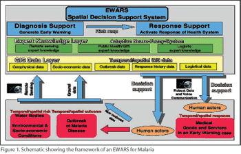 There are three EWARS projects under consideration by the collaborative group one looking at Chikungunya infection in Kerala, India, the second Cholera in West Bengal, India and the third Malaria in South Africa. The findings from these projects will be integrated further extending the work possible on a given budget as well as minimising the time required to get concrete results. The EWARS will be made available to interested regional and national governments once fully developed for ongoing use and integration with the existing public health and IT infrastructure. The software will also be made available as an open-source, free of cost product to anyone who wishes to use it or build upon it.
Overview of EWARS Design and Implementation
-
Remote sensing and GIS data would be obtained from existing databases with the government/ science councils and research groups. This would be supplemented by field data (both existing and specifically collected for the project). Standardised data formats will be adopted wherever feasible to ensure the usability of data in the open source system and in existing commercial IT infrastructure.
-
Risk mapping would be carried out using the known variables as well as additional factors that may have weightage from a public health perspective.
-
Retrospective analysis using a case-control approach of RS and GIS data from selected areas within provinces under study would initially be used for validating the risk mapping followed by prospective data collection.
-
An automated risk score would then be developed using such that the geographic area where the greatest public health threat is deemed present would be given the highest rating.
-
Resources to deal with the identified problems would be automatically recommended for allocation based on the database of existing resources that would be compiled as part of the system with an adaptive “fuzzy-logic” methodology [Classical mathematical logic operates with statements and rules that can be uated as “true” or “false” (1 or 0 respectively). Rule based systems in the public health sector have to deal with statements that have a degree of truth ranging between 0 and 1. Fuzzy logic methodology is an innovative and scientifically sound approach to implement decision support in this complex environment.
-
The areas under surveillance would be reviewed using GIS and field data on a defined schedule to determine if the identified problems have been resolved or reduced in severity by intervention of the public health system. The utility of microwave imaging in acquiring useful data when standard optical sensing is rendered inoperative due to the monsoon cloud cover will also be uated.
-
Risk scoring would change automatically and dynamically based on updated system inputs and resources would be automatically recommended for allocation in real-time based on the revised list of highest threats.
-
The proposed system is a comprehensive Decision Support System. It supports health service administration in risk uation and allocation of resources based on risk scores. Feasibility and acceptance of EWARS at the level of administration, users and general populace will be systematically studied using both quantitative and qualitative methods incorporating elements of action research methodology, community-led development theory and construtivism theory along with more traditional approaches such as models and case studies. Economic analysis and variable assessment will also be a part of the EWARS model.
Since we will be working closely with the government agencies for project piloting and implementation, costs incurred for elements like satellite imaging, delivery of “on-the-ground” interventions and so on will be largely borne by the government thus maximising our available resources. The specific deliverables during the initial pilot phase would be (1) Design and deployment of the EWARS system with data collection from 2 locations in the given state/province. This includes a web interface, mathematical modeling on the back-end, training of concerned project assistants and governmental personnel (2) Data Analysis and refinement of the mathematical model as well as the software (3) Prospective validation of the EWARS in terms of prediction, efficacy in supporting resource deployment and acceptability by public health users. If the EWARS pilot study is successful, additional insights gained from the pilot will be incorporated into the EWARS following which a full-scale deployment projects can be undertaken in consultation with the concerned governments and scientific research councils.
Challenges
While the concept we have advanced may have much that is theoretically desirable, it is clear that there are a number of significant practical challenges that will need to be surmounted.
Funding- For extension of the work to cover areas/populations in sizes that will make a genuine impact on public health, a significant investment in informatics, human resources and supporting material will be required.
Change management- Though the informatics scaffold is intended to be unobtrusive for the vantage point of the day-to-day staff, there may still be resistance to change among the public health operatives and other stakeholders, which can adversely affect the implementation of the EWARS. There will also be need for an unprecedented degree of multidisciplinary cooperation to ensure the smooth deployment of an EWARS.
Availability- Remote sensing imagery is not uniformly available, and even if it is, may not have the optimal temporo-spatial properties. Particularly in the Indian sub-continent, the onset of the monsoon can cause substantial impediments to acquiring useful imagery of the geographical areas of interest. In India, fortunately, ISRO has played a leading role in advancing satellite-based health related applications like telemedicine and they share the interest of the AT 6 group in using RS data for epidemic prevention and control.
Conclusion
A comprehensive EWARS that employs multimodal scientific inputs can form an important part of the public health framework to predict and prevent vector-borne diseases by providing real-time risk mapping and specific decision support to public health workers and government authorities. 

 Like
Like
 Dislike
Be a part of Elets Collaborative Initiatives. Join Us for Upcoming Events and explore business opportunities. Like us on Facebook , connect with us on LinkedIn and follow us on Twitter , Instagram.
"Exciting news! Elets technomedia is now on WhatsApp Channels Subscribe today by clicking the link and stay updated with the latest insights!" Click here!